
Construction Scanning
Millimetre-accurate LiDAR and drone surveys for construction, architecture and heritage. Visualskies captures existing buildings and sites as measured point clouds and photoreal 3D models, so design teams, engineers and planners work from the real thing. One dataset, from viability to handover.
3D scanning for the built environment
Construction scanning captures existing buildings and sites as measured 3D data, so architects, engineers and planners design from the real thing rather than an approximation. Terrestrial LiDAR gives a survey-grade backbone accurate to a few millimetres, and drone photogrammetry covers roofs, facades and areas that are slow or unsafe to reach on foot.
We register every scan in Leica Cyclone, align photography to the locked LiDAR in RealityScan, and check the result against numbers rather than by eye. The point clouds import directly into Revit and AutoCAD, and the same data can become a photoreal site model for planning and marketing.
The aim is one continuous dataset, captured once and reused from the first viability check to the final sale. Read how that works in our guide to LiDAR and Gaussian splatting across the AEC lifecycle.
What you get
- Point cloudsRegistered, georeferenced and RGB-coloured, at the densities your design team needs.
- CAD and BIM readyImports straight into Revit and AutoCAD.
- Textured modelsPhotogrammetry meshes for detail, condition and documentation.
- Photoreal site modelsGaussian splats for stakeholder reviews, planning and marketing.
From viability to handover
Viability
A drone flight and a Gaussian splat model put a photoreal view of the site in front of a committee within 24 hours, before any survey fees are committed.
Measured survey
Terrestrial LiDAR and drone photogrammetry record existing structures to millimetre accuracy, including roofs no one can safely walk on.
Planning
Accurate aerial photography and models ground CGIs and visualisations in the real site, so proposals are easier to understand and approve.
Restoration
Detailed records of historic and fragile structures, captured without scaffolding where access is limited.
Construction scanning in practice
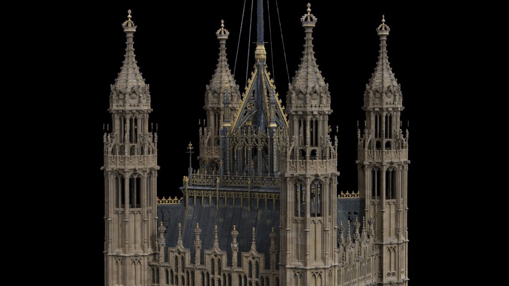
Houses of Parliament
UK Parliament
Models of the Palace of Westminster, with a heavy-lift drone flown inside the Central Tower instead of scaffolding.
Read the case study
Smithfield Market
General Market restoration
Laser scanning paired with drone photogrammetry of the General Market, including a fragile roof where access was not permitted.
Read the case study
Imperial College London
Design and restoration
Facades and stonework captured as measured, textured models so the design team works from the building as it is.
Read the article
Woking
Viability review
From drone flight to a photoreal site model in front of a development committee within 24 hours.
Read the article
Ransome’s Wharf
London Square
Scan data carried through construction monitoring and on into a 3D marketing platform for the development.
Read the article
Crystal Palace FC
AVR London
Aerial photography that helped AVR London create the planning CGIs for the club’s new training ground.
Read the case studySurvey-grade kit, checked by numbers
Terrestrial LiDAR
- Leica RTC360 for high-volume interiors: 1.9 mm 3D point accuracy at 10 m
- Trimble X7 for rapid scanning
- Leica P50 for long-range facades, towers and large sites, with a reach of more than 1 km
Aerial
- DJI Matrice 300 RTK with a 61 MP full-frame Sony camera
- DJI Mavic 3 and Mini 5 Pro for fast coverage and tight spaces
- Enhanced CAA and EASA permissions to fly within 10 m of uninvolved people
Processing
Every scan is registered in Leica Cyclone and checked against registration and control point residuals. Photography is aligned to the locked LiDAR in RealityScan, so textured models and Gaussian splats share the same survey geometry.
Delivery
Registered, georeferenced and RGB-coloured point clouds for Revit and AutoCAD, textured meshes, and photoreal Gaussian splat models for reviews, planning and marketing. Read how we deliver millimetre-accurate scans.
Ready to Brief Us?
Tell us about the site, what you need from the data, and when. We will come back with the right survey approach, crew and schedule. No obligation, no spreadsheet to fill in.