Visualskies is a growing London-based tech company providing surveying services for film, TV, music, heritage, reality capture and construction. The Visualskies team, set up in 2016, is made up of architects, archaeologists, surveyors and visual effects artists, working together to deliver high-definition 3D mapping and virtual reality environments as well as aerial-based filming and photography. For laser scanning, Visualskies exclusively use Leica Geosystems equipment. Here, Duncan M B Lees, 3D Scanning Specialist, Visualskies explains why laser scanning is the perfect tool for deadline-driven TV work.
A competitive edge: the latest in laser technology
Because our work is so varied, we need to create bespoke solutions for every project. That means that we have built a comprehensive toolbox of hardware and software, based on our accumulated experience. To set ourselves apart from the many other companies that also digitally document the world around us, we offer both highly experienced consultancy and the best technical tools available.
Our hardware includes state-of-the-art Terrestrial Laser Scanning (TLS) technology. For long range terrestrial laser scanning we use the Leica ScanStation P50, arguably the fastest and safest long-range 3D laser scanner currently available, able to perform at extreme temperatures. The fast Leica RTC360 laser scanner is perfect for projects with a smaller geospatial footprint. It has been a game changing addition to our 3D reality capture capabilities. We can now collect over twice as much data in any working shift or, more importantly, halve our time capturing data at any location.
Revealing hidden details: using LiDAR to penetrate vegetation
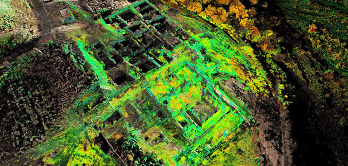
Many of our projects have been in areas that exhibit dense vegetation that masks the ground surface from the naked eye.
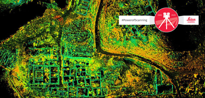
3DReshaper (Leica Cyclone 3DR) software provides us with the ability to strip away the tree cover and visualise what lies below; something that has had a startling impact on many of the projects we have undertaken at home and abroad. It is a perfect solution for cleaning, segmenting and filtering point clouds, which has proved particularly efficacious when we are analysing our reality capture data.
For example, for a recent project – a TV show for National Geographic, Lost Cities with Albert Lin, made by Blakeway Productions – we needed to document an historic site rendered almost invisible by the aggressive invasion of mangrove forest. To allow the team to literally reveal the lost city of Nan Madol we used 3DReshaper to penetrate the vegetation canopy and find the remains that, to the naked eye, were hidden underneath.
Fast laser scanning and processing lets us deliver under pressure
Being able to deliver results quickly is often critical to winning business.
Using the same project as an example, the schedule for the whole Lost Cities series was incredibly compact; with digitally documenting the numerous sites, visualising the remains and filming the whole program all being undertaken in one relatively short concurrent timescale.
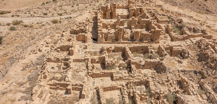
The first challenge was to capture the entire site of a Nabataean temple at Khirbet al-Darieh in Jordan in a single day. Intense sunlight made our job more difficult because we needed flat lit, shadow-free images. Over the course of the day, the ScanStation P50 was positioned in and around the temple complex to collect 102 separate scans at key locations. Roughly every third or fourth 360° scan was collected with full RGB colour, something which later facilitated the alignment of the LiDAR point cloud and images during post-processing.
Additionally, thousands of aerial and terrestrial images were captured after the sun had gone down, creating a substantial flat lit image data set. Following the initial registration of the LiDAR set ups in Leica Cyclone and the post-processing of all the images, a ‘first pass’ model was calculated, enabling the team to get an on-screen visualisation of the remains in only a few hours. Subsequently, the full 3D model was calculated from carefully selected inputs comprising a mix of LiDAR and images. Overall, creating the high-resolution 3D model of the Khirbet al-Darieh temple and surrounding hinterland was half an hour short of 24 hours.
Using the latest reality capture technology allows our highly experienced team to deliver beyond client expectations of what’s possible, both in terms of detail and speed. Delivering precise, photo-realistic, high fidelity visuals in quick time across a number of platforms repeatedly garners us the approbation of those we work with, not only in film and TV, but in all sectors. It is our privilege and pleasure to work with exceptional professionals in incredible places around the world, dovetailing our bespoke solutions into the creative process to produce breath-taking results.
Duncan M B Lees
3D Scanning Specialist
Visualskies
Duncan’s extensive experience in all aspects of 3D has evolved through leading multi-disciplinary, multi-talented teams within a number of markets; with particular reference to the forensic and security, film & television VFX, architectural and heritage industries. He is now utilising this experience as the 3D scanning specialist at the ultimate drone specialists Visualskies; one of the best drone-based data capture companies in the world, providing an integrated terrestrial and aerial data capture, processing, presentation and interpretation service for myriad markets.
Duncan is one of the leading exponents of terrestrial LiDAR scanning, cyber scanning, close range laser scanning and professional photographic services to the plethora of sectors in which he works. From GPS setting out of locations and sets through to the sub millimetre scanning of bodies, weapons, props, objects and maquettes – via data wrangling, environment, set and location scanning, full 3D modelling and the scanning and modelling of heads and bodies – Duncan is adept and experienced in all these forms of work.
Client
Blakeway TV Productions
What We Did
3D Surveying and Photography and Video
Series
National Geographic “Lost Cities”