

Imagine capturing an entire movie set, every detail, every angle in under an hour. What once took days of manual scanning can now be accomplished before lunch. Here’s how we’re revolutionising 3D environment capture for the film industry…

At Visualskies, we’re pushing the boundaries of 3D environment capture by combining LiDAR precision, photogrammetry’s visual fidelity, and the revolutionary speed of Gaussian splatting. The result? Environment scans that capture extraordinary detail while dramatically reducing processing time.
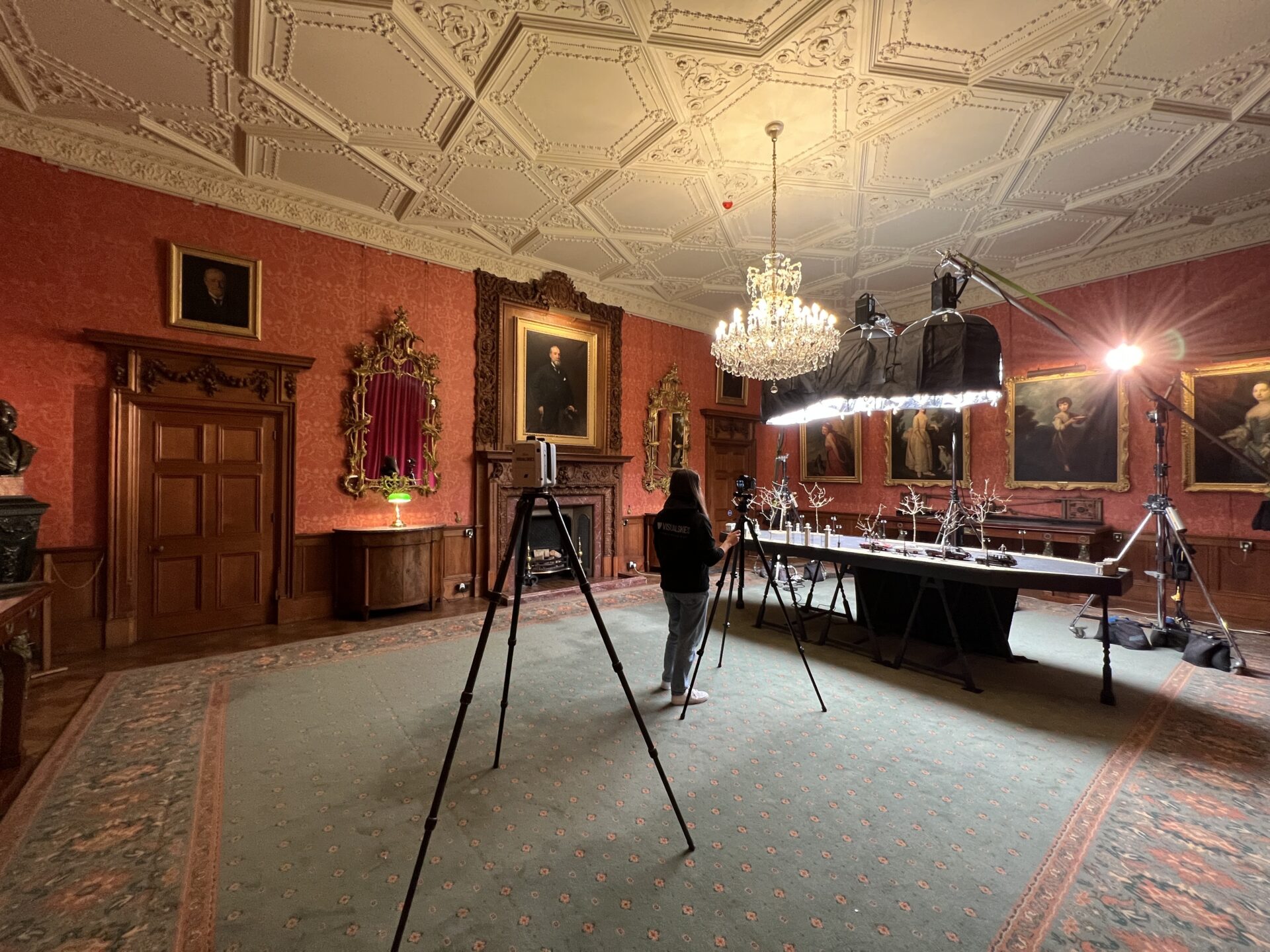
We recently put this breakthrough workflow to the test alongside our partners at Heliguy. Armed with a DJI Matrice 4E drone and the Xgrids L2 Pro mobile scanning rig, we achieved something remarkable: environmental scans that are not only faster than traditional methods, but also deliver unprecedented accuracy. For anyone working in VFX, previs, or virtual production, this represents a fundamental shift in how we can capture and recreate real-world environments.
Taking the Headache Out of Virtual Production
Shooting on location has its charm, but it also comes with permits, weather delays, travel logistics, and tight schedules. What should be a simple exterior scene can quickly turn into a multi-day, budget-draining operation.
That’s where virtual production, powered by our hybrid scanning workflow and Gaussian splatting, offers a smarter alternative.
Using the DJI Matrice 4E for aerial coverage and the Xgrids L2 Pro for ground-level detail, we quickly capture real-world environments with stunning fidelity. Then, instead of spending weeks building traditional 3D assets, we use Gaussian splats to bring those scans directly into real-time engines — no meshing, no texturing, just fast, photoreal environments ready for LED walls or in-engine rendering.
The result? You get the realism of a real-world location, without ever leaving the stage. It’s not about replacing traditional filmmaking – it’s about removing the pain points and unlocking creative flexibility.
Our Hybrid Scanning Solution
Combining the best of aerial and ground-based technology

DJI Matrice 4E
Aerial Photogrammetry
- 20MP Hasselblad camera
- 45-minute flight time
- Automated flight paths
- RTK positioning accuracy
- Wide area coverage

Xgrids L2 Pro
Mobile LiDAR System
- 32-beam LiDAR scanner
- 360° field of view
- 100,000 points/second
- 2cm accuracy
- Ground-level detail
Traditional Scanning
The Old Way
- 1 day capture time
- Multiple operators needed
- Limited coverage area
- Weather dependent
- High equipment costs
Gaussian Splatting
The Future
- Under 1 hour capture
- Single operator possible
- Unlimited area coverage
- All-weather capable
- 70% cost reduction

What this Approach Achieves
Here’s where the magic happens. Once our hybrid capture was complete, we fed the data through Gaussian Splatting — a breakthrough technique that doesn’t just process point clouds, it transforms them into production-ready assets. This revolutionary method delivers streamlined workflows that accelerate everything from early previsualization to final set construction, dramatically reduced processing that cuts traditional render times by up to 80%, and cinema-grade quality that integrates seamlessly into Unreal Engine and other real-time platforms. The results speak for themselves:
Collaboration with Heliguy: Bringing It All Together
In our recent proof-of-concept, the combined scans were processed as a splat and visualised within a virtual production pipeline. In under a day, we had:
Visualskies on site with Heliguy for our recent collaboration
What You Can Do With It
Industry Applications
Transforming workflows across multiple sectors
Visual Effects & Film Production
Revolutionize your production pipeline with photorealistic 3D environments ready for virtual production. Our Gaussian splatting workflow delivers film-ready assets in a fraction of the traditional time.
- Virtual ProductionLED wall-ready environments for in-camera VFX
- PrevisualizationRapid location scouting and shot planning
- Set ExtensionsSeamless integration with live-action footage

Architecture & Construction
Document existing conditions with unprecedented accuracy. Perfect for renovation projects, BIM integration, and construction progress monitoring.
- As-Built DocumentationAccurate 3D records of existing structures
- Progress MonitoringTrack construction phases with time-series scans
- BIM IntegrationDirect import into Revit and other BIM software

Heritage Preservation
Create permanent digital records of historical sites and artifacts. Our non-invasive scanning preserves cultural heritage for future generations.
- Digital ArchivingPermanent records of at-risk heritage sites
- Virtual MuseumsInteractive 3D exhibitions accessible worldwide
- Restoration PlanningDetailed baseline data for conservation work
Gaming & Metaverse
Transform real-world locations into interactive game environments. Our optimized workflows deliver game-ready assets that maintain photorealistic quality.
- Environment DesignReal-world accuracy for immersive gameplay
- VR/AR ApplicationsOptimized models for real-time rendering
Key Technical Terms
WHERE TO FIND US?
Visualskies is proud to offer our expert Photogrammetry services for VFX across multiple locations worldwide. Our presence in key cities enables us to provide prompt and efficient service to our clients. You can find us in the following locations.
Mobile Photogrammetry Rigs VFX London
5 Havelock Terrace
Battersea
London
SW8 4AS
United Kingdom


You May Also Like
 Digital Archaeology: Using 3D Scan Data to Unveil the Hydrological Secrets of Petra
Digital Archaeology: Using 3D Scan Data to Unveil the Hydrological Secrets of Petra
 Visualising Possibility: How Visualskies Powers Art & Immersive Experiences
Visualising Possibility: How Visualskies Powers Art & Immersive Experiences
 Using Ethical AI Training to Drastically Cut Previs Time (Without Scraping Artists’ Work)