Overview
Blakeway Productions tasked Visualskies with aiding explorer Dr. Albert Yu-Min Lin to bring together his unique blend of adventure, science and archaeology to make headline-grabbing new discoveries in a groundbreaking new television series for National Geographic. The result is Lost Cities which combines hi-tech science, breath-taking visuals and genuine exploration to bring to life some of the most extraordinary sites of antiquity.
Visualskies are proud to have been asked to apply our unparalleled experience and bespoke approach to 3D scanning, both on the ground and in the air, landscape interpretation and spatial data visualisation to realise the ambitions of National Geographic for the series. We worked closely with Albert and the Blakeway crew to develop a narrative based upon a scientific approach to the collection of spatial data, revealing secrets from the past long forgotten by the passage of time. The result is a series of ambitious programmes that deliver powerful, emotional stories with our hi-tech imagery to bring the mysteries of the past vividly into focus in the present.
Having spent three days travelling via Japan and Guam, the Visualskies crew eventually landed on Pohnpei to join the rest of the crew; tired, jet-lagged but with a keen sense of anticipation for the challenging work ahead. Located in the Pacific Ocean, Pohnpei is a high island of volcanoes forged millennia ago. Now part of the Federated States of Micronesia, Pohnpei is swathed in lush tropical rainforest and is one of the most verdant and wettest places on earth, with rainfall well in excess of 5 metres per annum. It rains pretty much every day; it was a good job that the Visualskies crew and kit were largely waterproof.
Project
Lost Cities With Albert Lin
Client
Blakeway Tv Productions
What We Did
3D Surveying; DTM extraction; CGI ‘onscreen’ content
Watch the Lost Cities Teaser here

https://www.nationalgeographic.co.uk/video/tv/lost-cities-albert-lin
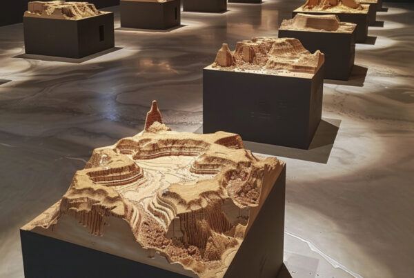
The main focus of the programme, the awe inspiring Nan Madol, is an archaeological wonder adjacent to the eastern shore of Pohnpei. Few places in the Pacific, indeed on the planet, are as intriguing and mysterious as Nan Madol. Hardly known outside Micronesia, the lost city of Nan Madol is a hidden gem of Polynesian history and culture and is an awe inspiring sight for modern people lucky enough to visit or work there. The name Nan Madol means ‘within the intervals’ and is a reference to the canals that criss-cross the ruins. The city, constructed in a lagoon, consists of myriad artificial islands linked by this network of canals. The core of the site, with its monumental basalt block walls and coral filled platforms, encompasses an area of over 18 square kilometres and is the only extant ancient city built on top of a coral reef. Nan Madol was the ceremonial and political capital of the Saudeleur Dynasty until the early part of the 17th century; although Nan Madol was the scene of human activity since the 1st or 2nd century AD, the construction of the distinctive basalt block architecture probably began in the 12th century. The colossal scale of the beautiful edifices, their technical sophistication and the extraordinary density of the megalithic structures bear testimony to the complex social and religious organisations of the island society at this time. In the north eastern part of the site lies the breathtaking Nan Doas with walls of impossibly massive basalt blocks, in places over 7 metres tall. These surround a central tomb in an impressive courtyard that was built for the first Saudeleur. These elaborate ruins represent the ceremonial centre of the Saudeleur Dynasty; a vibrant period in Pacific Island culture. According to local legend, the basalt blocks used in the construction of Nan Madol were flown to the site by twin sorcerors Olisihpa and Olosohpa using black magic. Although archaeologists have located several quarry sites for the basalt at the opposite end of Pohnpei, the method of transportation and construction of these incredibly heavy stone blocks has still not been adequately explained. The longer you spend at Nan Madol, the more these legends indeed seem to be a reasonable explanation as to how the place was built.
The site is inscribed on the List of World Heritage in Danger due to a number of threats, notably the silting up of the waterways and the unchecked, rapid growth of the mangroves and other vegetation that undermine and otherwise destabilise the remains. The majority of the megalithic complex at Nan Madol has been rendered almost invisible by the aggressive invasion of the mangrove forest and other vegetation that proliferate in the tropical climate on Pohnpei. As a corollary of this it was impossible to document, digitise and visualise the remains using any traditional survey techniques. There was simply too much vegetation to be able to allow more than a tantalising glimpse of disparate parts of the widescale megalithic structures; so an alternative methodology had to be utilised. To allow the team to literally find the lost city of Nan Madol Visualskies used our drone mounted LiDAR technology to penetrate the vegetation canopy and reveal the remains that, to the naked eye, remain hidden underneath. Working under intense pressure to fly multiple sorties every day, in far from ideal weather conditions, with no power close at hand and then to process and visualise the results in a matter of days, Visualskies pushed the technology, the hardware, the software and the team members to their limits and beyond. For the team from Visualskies, working on Pohnpei was an incredible journey into the past and a unique professional experience on a tropical paradise.
Location Images


The Tools We Deployed


Surveying the citadel
Aerial LiDAR
Deploying the GEOslam Zeb horizon paylod on our DJI M600 pro gave us a flight time of 25 minutes, which enabled us to scan an incridibly large section of dense jungle canopy in a short space of time.